Geography
Westrim occupies the northwestern quadrant of Rimihuica, dominated by the massive Dunes of Kunagi desert and ringed by mountains and deadly jungles. This is a land of extremes—scorching desert sands, impenetrable jungle, and the mountain fortresses of dwarven city-states.
Boundaries and Position
- North: The Eronia Range forms the northern boundary, separating Westrim from the Tarkhon Empire. This mountain range includes several smaller ranges home to dwarven city-states.
- East: Transitions into the Innerrim jungle basin
- South: The Ishnit Jungles wrap around the southern edge of the Dunes of Kunagi
- Southwest: The Agreben Sea and the Greenwater Isles
- West: The Western Isles lie offshore; the state of Mueras occupies the western coastal region
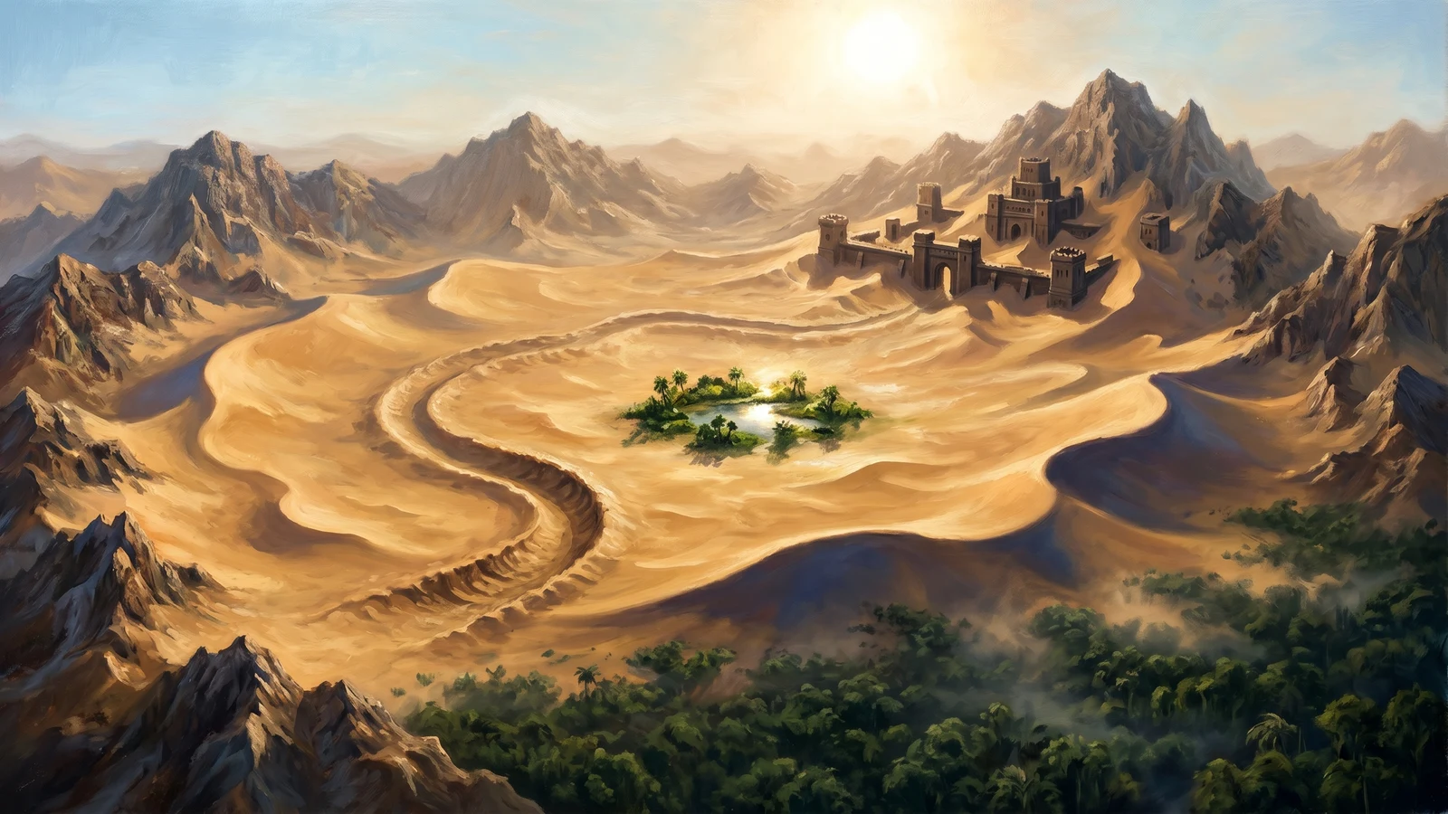
Dunes of Kunagi
The dominant feature of Westrim—a vast, kidney-shaped desert of golden sand stretching across the interior. Home to giant sand wurms reminiscent of Dune. The only reliable water source for hundreds of miles is Benshu's Promise, an oasis guarded by a deadly sphinx who demands riddles be answered before any may drink.
Ishnit Jungles
Covering the entire southern side of the Dunes of Kunagi, the Ishnit Jungles are among the most dangerous wilderness areas in Alaria. Home to the Naruaghin people and countless deadly monsters. Notable locations include:
- Ekomorn: A rift extending to the center of the material plane, feared by all
- Demonwatch: A darkstone palace on the southern cape, overrun by confined but immortal demons
Eronia Range
The northern mountain barrier, home to multiple dwarven city-states nestled among the peaks. These mountains catch moisture from the north, contributing to the rain shadow that creates the Dunes of Kunagi.
Surrounding Seas
- Agreben Sea: Southwest of Westrim, south of Mueras, west of the Ishnit Jungles
- Gulf of Norag: South of the Ishnit Jungles
Political Climate
TODO
What Makes It Interesting
TODO
What Will Go Wrong
TODO
Husakas
A desert region in the southwest Dunes of Kunagi, roamed by scorpion riders who have adapted to the harsh conditions. The water here carries a terrible curse—drinking causes complete loss of long-term memory. This has shaped the Husakas people's entire culture around memory preservation and scorpion symbiosis.
See the full Husakas entry for the scorpion rider culture, the Twice-Born, and notable locations.
House of the Scorpion
A half-buried palace in northern Husakas where the Prince of Scorpions dwells—a tragic, transformed figure who maintains all scorpions in the desert. The Husakas make bicentennial pilgrimages here, trading memories for the continued survival of their bonded mounts.
See the full House of the Scorpion entry for the Prince, the pilgrimage ritual, and why killing him would be catastrophic.
Gyerekas
The fossil reef hills marking Husakas's southern boundary—ancient coral formations and the bones of creatures from a vanished sea. The Husakas call it the Bone Garden. It serves as neutral trading ground and contains dangerous cave systems leading into unknown depths.
See the full Gyerekas entry for the reef's resources, the Leviathan's Rest, and the Dwellers Below.
Spotted Forest
Where the Dunes of Kunagi surrender to the savanna, the land fractures into scattered oases—the Spotted Forest. A patchwork of verdant islands fed by underground springs, home to the Spotted Ones (mixed Husakas-Chule descent) who serve as intermediaries between desert and grassland cultures.
See the full Spotted Forest entry for the oasis ecology, trading crossroads, and current tensions.
Mueras
The westernmost state of Rimihuica, Mueras occupies a stretch of brutally fragmented coastline where the land has shattered against the sea. Cliff-walled islands, treacherous channels, and hidden harbors define this region—geography that created the merchant-king oligarchy. Those who know the waters control the trade; those who control the trade rule Mueras.
The coast runs roughly 400 miles north to south, from the Mueras Highlands and Hammer Coast in the north to the Beak of Mueras peninsula in the south. Inland, the arid Dustwind Plateau separates the wealthy coastal cities from the darker eastern reaches—the Taflex Forest, Grimreach, and the shadow-haunted Darkened Coast.
Key features include:
- Labyrinth Sound: A maze of treacherous channels controlled by pilot guilds loyal to the merchant-kings
- Corpse Bay: Waters where the dead wash ashore with disturbing regularity
- Kaspion: The old capital, death-cursed when King Kasper fell 118 years ago, now a ghost-haunted ruin
- Bazz: The de facto capital, seat of the Council of Seven merchant-king houses
- The Darkened Coast: A stretch of shoreline perpetually shrouded in shadow, home to dark-attuned sea creatures
- Sal'emri Bay: Tarkhon trading enclaves maintaining careful neutrality in merchant-king politics
See the full Mueras entry for detailed coverage of settlements, merchant houses, and regional hazards.
Atriik
A confederation of four city-states in southwestern Westrim, occupying the territory between the Milras Forest (north), the Dunes of Kunagi (east), the Bloodlands and Ishnit Jungles (south), and Shark Bay (west). The Kor and Sharabha peoples here share a culture of elaborate courtesy that masks constant political maneuvering.
Key features include:
- The City-States: Lupuno, Byonowidi, Shinii, and Wykakas—three Kor monarchies and one Sharabha
- Mykala: A ruined fortress at the base of a colossal tree (30-mile canopy), sacred to all four city-states
- Milras Forest: Dense old-growth woodland containing the time-warped ruins of Milreun Palace
- Fatiik Forest: Contested woodland on the Naruaghin border
- Sprenwood: Managed coastal forest providing timber and furs
- Shark Bay: Maritime access controlled by the Kendor sea-folk of Watalina
- The Bloodlands: Scarred buffer zone between Atriik and Naruaghin territory
- Kunagi Hills: Eastern transitional zone, gateway to the desert trade
See the full Atriik entry for detailed coverage of the city-states and regional features.
Emyrron the Vile
A dragon of Westrim.
TODO
Enapay
The ancient Dwelyn monarchy occupying the Green Wilds at the edge of the Ishnit Jungles. Enapay has been the Dwelyn homeland since before written history, its queens bonded to the emerald dragon Surrey Mahaila through a ritual known only to the royal line.
For full details on government, culture, and current crisis, see the state entry: Enapay
Territory
Enapay claims the entirety of the Green Wilds, though effective control extends only as far as Dwelyn settlements and patrol routes. The nation's heartland lies along the Ishtar River, with the capital Lise at its delta. Eastern territories—the Green Marches—remain contested with East Naruaghin tribes.
The nation has no coastline. The Gulf of Norag lies thirty miles south of Lise, but Naruaghin tribes and cursed waters prevent direct access. All trade flows overland or upriver.
Key Locations
- Lise: Capital city, seat of Queen Teyara Greenmantle
- Green Wilds: The forest territory Enapay claims
- Dragon's Roost: Surrey Mahaila's lair, built into a colossal tree near Lise
- Ishtar Ford: Contested border crossing with East Naruaghin
- The Green Marches: Vulnerable frontier settlements
Juda's Perch
TODO
Mount Kthaki
TODO
Senwyn the Agonizer
A dragon of Westrim.
TODO